📍 Destination Overview
Vik is at Iceland's southernmost tip on the self-drive Ring Road, famed for Reynisfjara's black-sand beach, where basalt is ground into jet-black sand. The cliff is lined with pipe-organ basalt columns, and black offshore stacks are said to be trolls turned to stone; rip currents make staying above the waterline vital. A red-roofed white church is the village's signature.
🏖️ Location
Iceland · South Coast · Iceland's Southernmost Village
🗓️ Best Season
Jun-Aug (Summer) / Sep-Mar (Aurora)
🕐 Time Difference
-8 vs Beijing
💰 Currency / Language
Icelandic Króna ISK / Icelandic, English
🕐 Suggested Duration
Half day - 1 day · Black Beach + Basalt Columns + Church
🔌 Outlet / Voltage
Type C / F outlets · 230V · adapter needed
☀️ Best Time to Visit & Climate
🌌 Winter: Sep–Mar
Aurora hunting along the south coast.
☀️ Summer: Jun–Aug
Long days — puffin watching season.
Jan
🌌
4°/0°
Aurora
Feb
🌌
4°/0°
Aurora
Mar
🌌
5°/0°
Aurora
Apr
🌤️
7°/2°
May
🌷
10°/5°
Jun
☀️
12°/7°
Best
Jul
☀️
14°/9°
Best
Aug
🌤️
13°/8°
Best
Sep
🌌
11°/6°
Aurora
Oct
🍂
8°/3°
Aurora
Nov
🌌
5°/1°
Aurora
Dec
❄️
4°/0°
Aurora
📷 Top Attractions
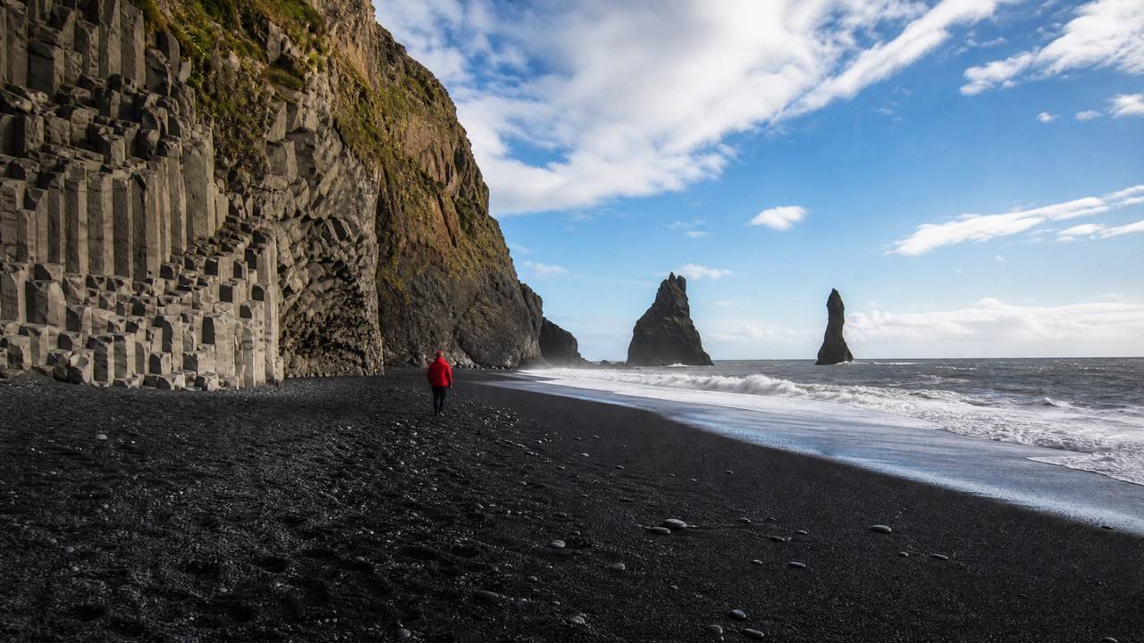
Reynisfjara
Reynisfjara ('Reynir's beach', named after the Reynir farm of Iceland's settlement era) lies on the South Coast just west of Vík, about 180 km and 2.5 hours' drive from Reykjavík - Iceland's most famous and most dangerous beach, drawing close to a million visitors a year. The black sand is basalt ground down by Atlantic surf, contrasting with white breakers and green cliff tops; offshore stand the three Reynisdrangar sea stacks, about 66 metres at their tallest, trolls petrified by sunrise in folklore while dragging a ship ashore. At the northern end the Garðar cliff stacks continuous hexagonal basalt columns 30-60 centimetres across, and the Hálsanefshellir sea cave is roofed with the same. Puffins nest on the Reynisfjall cliffs from roughly April to August, and the beach has starred in Game of Thrones and Rogue One: A Star Wars Story. Safety comes first: this is the only Icelandic beach with an official warning-light system, installed in 2022 - on yellow, keep well back from the waterline and out of the yellow zone; on red, the lower beach, basalt columns and cave all close. Sneaker waves arrive every 5-10 minutes without warning, far larger and further up the beach: five people drowned between 2007 and 2024, and in August 2025 a nine-year-old girl was swept from the basalt cave. The rules: never turn your back to the sea, stay at least 30 metres from the waterline, never walk to the water's edge even for a second, and watch children; if a wave hits you, drop flat and dig your hands into the sand rather than trying to run. February 2026 winter erosion also collapsed part of the basalt columns and reshaped the beach, with safe zones re-marked - check safetravel.is before travelling. Entry is free and open around the clock; parking is about 1,000 ISK payable via the Parka app, with toilets and a small cafe.
Beach & Island

Dyrhólaey
Dyrholaey is a 120-metre promontory about 20 km west of Vik on Iceland's south coast, its name meaning 'the hill with the door-hole'. It began as a volcanic island born of an undersea eruption at the end of the last ice age, later joined to the mainland by drifting sand. The Atlantic has cut a natural arch roughly 43 metres wide through the cliff base, large enough for small boats in calm seas and, in 1993, for an Icelandic pilot flying through. At the summit stands a square concrete lighthouse from 1927, automated in 1978. From the top the view runs east to Reynisfjara and the Reynisdrangar stacks, north to the Myrdalsjokull ice cap over the Katla volcano, and west along an unbroken line of black sand to the Westman Islands. A protected nature reserve since 1978, the upper area closes overnight from about mid-May to late June so puffins and Arctic terns can nest, and daytime hours are often limited to 09:00-19:00, so check the signs at the entrance before you go.
National Park & Nature

Dyrhólaey
Dyrhólaey is a basalt headland on Iceland's south coast pierced by a giant natural arch carved by the waves, wide enough for seabirds and even small aircraft to pass through. Each summer thousands of puffins nest on its cliffs, and from the top you survey the black beaches and Reynisfjara in full. It is a favourite south-coast spot for birdwatching, the arch and summer sunsets.
Viewpoint
No.4 Vik
Fjaðrárgljúfur
Fjaðrárgljúfur is one of Iceland's most stunning canyons. About 100 m deep, 2 km long, it features moss-covered walls, clear streams and an ethereal atmosphere — one of South Iceland's most memorable landscapes. Carved by glacial river over millennia. Green moss-covered basalt walls. Walking trails along the rim. Near Route 1; ~15 min walk from parking.
National Park & Nature

Solheimasandur Plane Wreck
Sólheimasandur Plane Wreck is Iceland's most iconic photo landmark. A 1973 US Navy DC-3 crashed on the black sand beach — rusted fuselage against desolate landscape — a global social media phenomenon. 1973 US Navy DC-3 crash landing; all survived; plane abandoned. Rusted fuselage on black sand beach. ~4 km walk from parking (about 45 min one way).
Historic Ruins & Heritage
🎯 Vik Experiences
Black Beach
Surf on the black coast.
Basalt Columns
Pipe-organ-like rock walls.
Reynisdrangar
Black rocks of troll legend.
Red-Roofed Church
Overlook the black coast.
Find Puffins
The comical birds of summer.
Vík is a seaside village at Iceland's southernmost tip, on the Ring Road Route 1 south coast. It is famous for the stunning Reynisfjara black sand beach — jet-black volcanic sand, pipe-organ-like basalt columns and black offshore sea stacks, desolate and magnificent. Remember: the black beach has extremely dangerous rip currents and sneaker waves — stay far from the waterline and never turn your back to the sea. In summer, puffins can be seen on the cliffs, and aurora can be chased in autumn-winter. About 2.5 hours from Reykjavík, an important stop on the south-coast ring road.
🚌 Transport & Stays
City Transport
🚗About 2.5 hrs from Reykjavík (reference)
Car Rental / Self-drive
Ring Road Route 1 south coast
About 2.5 hrs from Reykjavík (reference)
🚌By itinerary (reference)
South Coast Day/Multi-day Tour
Includes black beach, etc.
By itinerary (reference)
🅿️Some paid (reference)
Sight Parking
Black beach parking
Some paid (reference)
🚶Mind safety (reference)
Walking
Beach & column trails
Mind safety (reference)
Recommended Stay Areas
🏖️ Vík Town (recommended)
Near black beach & church
🌌 Countryside Farms
Open area good for aurora
🏞️ Along South Coast
Stop on the ring road
🌋 Towards Glacier Lagoon
Midway lodging eastward
Free Consultation
Want to plan your Vik trip in more depth?
Tell us your departure city, travel dates and interests, and Usitour will tailor a trip just for you.