📍 Destination Overview
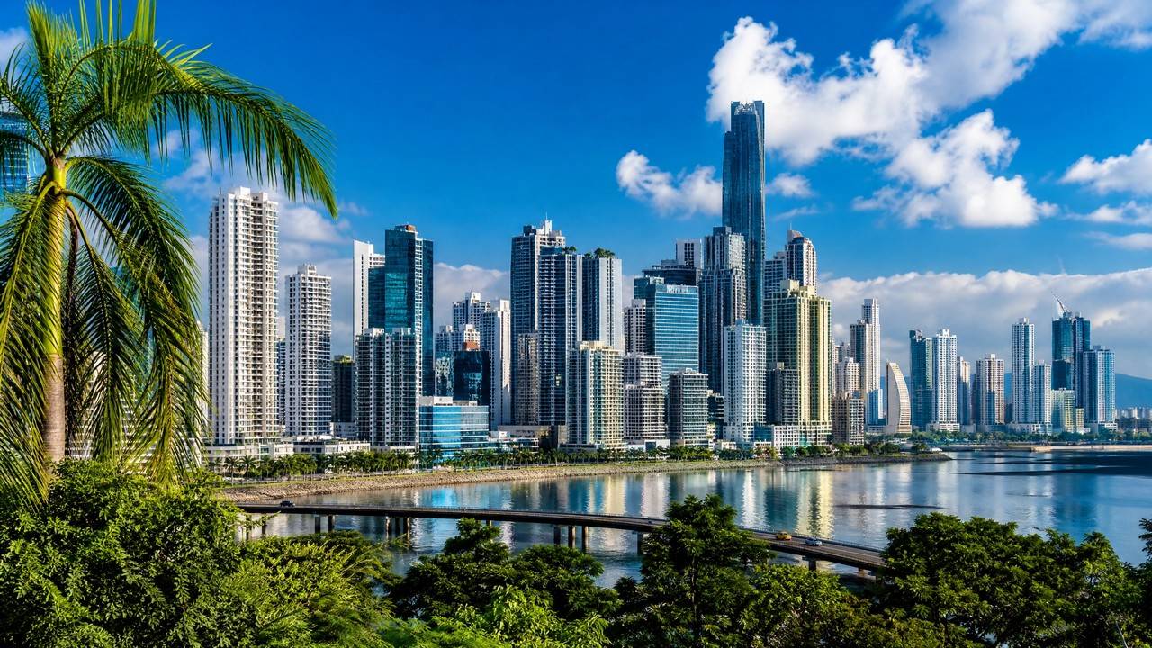
Panama City, capital of Panama, sits on the Pacific beside the canal's southern entrance. On one side soars a skyline of modern skyscrapers; on the other stands Casco Viejo, a UNESCO-listed colonial old town of churches, cobbled plazas and old-world charm. It holds the Panama Canal's Pacific gateway, near Old Panama's ruins and rainforest parks, best in dry season.
🏙️ Location
Panama · Pacific Bay · Modern Canal Capital
🗓️ Best Season
Best Dec-Apr (Dry season)
🕐 Time Difference
13 hours behind Beijing
💰 Currency / Language
US Dollar USD / Balboa PAB / Spanish, English in tourist areas
🕐 Suggested Duration
2-3 days · Skyline + Old Town + Canal
🔌 Outlet / Voltage
Type A / B outlets · 110V · adapter needed
☀️ Best Time to Visit & Climate
🌤️ Dry season: Dec–Apr
Dry and sunny—best for city tours and nearby islands.
🎉 Festival season: Jan–Feb
Carnival and street parades liven up the old town.
January
🌤️
31°/23°
Best
February
☀️
31°/23°
Best
March
☀️
32°/24°
Best
April
🌤️
32°/24°
Best
May
🌧️
31°/24°
June
🌧️
31°/24°
July
🌦️
31°/24°
August
🌦️
31°/24°
September
🌧️
31°/23°
October
🌧️
30°/23°
November
🌧️
30°/23°
December
🌤️
31°/23°
Best
📷 Top Attractions
More Attractions →
Casco Viejo (San Felipe)
San Felipe, the old quarter known as Casco Viejo or Casco Antiguo, is the historic district of Panama City, set on a peninsula cut off by the sea.
Why this old town exists: Panama City was founded on 15 August 1519 as Panama Viejo. In January 1671 the pirate Henry Morgan attacked and looted the city, and the governor Juan Perez de Guzman had it set on fire before the enemy arrived rather than let it fall into their hands, so the old city was almost totally destroyed. The new city was formally founded on 21 January 1673 on a peninsula completely isolated by the sea and ringed by a defensive wall system.
Form and change: three large fires in the eighteenth century altered the original layout, and the configuration you see today dates from the late nineteenth and first half of the twentieth century. That rebuilding inserted neoclassical and Afro-Antillean buildings among the ruins and colonial ones, which is what distinguishes it from old towns like Cartagena and Quito that are almost exclusively colonial.
Heritage status: inscribed on the World Heritage List in 1997 under the official name Archaeological Site of Panama Viejo and Historic District of Panama, reference 790, and extended in 2003. Note that this one inscription covers both the 1519 city ruins and the 1673 Casco Viejo: two halves of one property, not two separate sites.
Three details worth stopping for: the Arco Chato of the Santo Domingo convent, a flat arch that has stood for centuries without support and the most recognisable architectural detail in the quarter; the golden altar of the Iglesia de San Jose, which local tradition says was painted black and hidden to keep it out of Morgan's hands; and the Plaza de Francia, laid out in honour of French efforts on the canal and one of the best resting places on the seaward side.
Gentrification, which you should know about: the district has undergone marked gentrification in recent years, with restaurants, boutique hotels and nightclubs arriving in numbers and tourist pressure rising sharply. That has brought restoration money and commercial energy, along with the displacement of original and lower-income residents. It is a historic district and a community still changing.
Practical: the district is open at all hours and free to enter, half a day covers it on foot, dusk into night is the best atmosphere with rooftop terraces looking across at the new city's skyline, and after dark stick to main streets and lit routes while keeping phones and belongings close.
Old Town & Historic District

San Blas Islands
The San Blas Islands, officially Guna Yala, lie off Panama's northeast Caribbean coast near the Colombian border, made up of more than 365 coral islets under the Guna Yala indigenous comarca.
This is not an ordinary island resort: the islands belong to the Guna people, formerly Kuna, and the Guna General Congress governs tourism, issues the entry permits and licenses the operators, while the territory runs on its own rules. No road, ferry or commercial airline reaches the islands, and every visit has to be arranged through a Guna-approved operator or host. You come as a guest, not a customer.
Fees (2026): foreign visitors pay a US$20 entry tax in cash at the Carti checkpoint or the first island, collected by Guna authorities rather than the Panamanian government; Carti port adds about 2 dollars, and each island charges a further 2 to 5 dollars, so the fees come in stages.
There are no ATMs anywhere in the comarca, so bring all your cash from Panama City, and 50 and 100 dollar notes are often refused, so carry small bills. Your original passport is required and will be checked.
Getting there: pickup from your Panama City hotel between 5:00 and 5:30, a 4x4 drive of about two to three and a half hours over the Continental Divide to Carti port, then 20 to 40 minutes by lancha, roughly four hours door to door. The road to Carti needs a high-clearance 4x4, and rental companies prohibit ordinary cars from it. The alternative is a charter from Albrook's domestic terminal, about 45 minutes and roughly 400 dollars one way.
Two nights minimum: a day trip is technically possible, but three hours each way buys about five hours on the islands, leaving you exhausted with only a superficial look. Most trips run two to four nights from one island base, with thatched cabanas at about 80 to 130 dollars a night including three simple meals.
The Guna Congress bans scuba diving in the comarca, so only snorkelling and free-diving are possible.
Behavioural rules you must follow: ask permission before photographing any Guna person, and never photograph women without explicit consent; photographing military and government installations is prohibited throughout; ask before setting foot on inhabited islands; pack out all waste; light alcohol use is allowed in most tourist cabanas, but nudity and topless sunbathing are not.
Luggage: soft-sided duffel bags only, since large hard-shell suitcases are almost impossible to stow.
Season: December to April brings the calmest seas and best visibility, with January to March peak and booked early, and October to November the wettest. The real risks are logistical, namely rough crossings, sun exposure and the absence of medical facilities, so take out travel insurance that covers medical evacuation.
Beach & Island

Amador Causeway
The Calzada de Amador is a long causeway running out into the Pacific on the west side of Panama City, starting from the land near the Ancon district and linking four small islands in sequence, Naos, Culebra, Perico and Flamenco.
The causeway is made of rock dug out of the canal. Construction began in 1913 using spoil from the Culebra Cut, also called the Gaillard Cut, the hardest section of the canal. Engineers needed somewhere to dump millions of cubic metres of excavated material, and the result, entirely by accident, became one of the most scenic waterfronts in Central America. A later expansion used spoil from the 2016 canal widening project, so it is built from the physical remains of two generations of canal history.
Two things usually got wrong.
First, its length has never been officially published: tourism authorities say about six kilometres, other sources give four or eight, and the canal authority does not state one at all, the gap coming from different parties measuring different sections.
Second, it is four islands, not three. Many sources list only Naos, Perico and Flamenco and leave out Culebra, because Culebra has effectively merged with Naos and the Smithsonian's Punta Culebra Nature Center sits on it. The canal authority's official count is four.
Military past: from 1920 to 1980 these islands formed part of Fort Amador, a US military installation that with Fort Grant guarded the canal's Pacific entrance, and old gun emplacements and bunker remnants can still be found on the hillsides of Naos and Culebra. In 1999, as part of the canal transfer, the land returned to Panamanian sovereignty.
Access rules: free and open around the clock. This is a public road with pedestrian and cycling lanes, no gates and no ticket office.
Why the view is hard to replace: from the causeway you take in three things at once, the Bridge of the Americas, the canal's Pacific entrance with the ships at anchor, and the Panama City skyline across the bay. No second place in the city does that.
Three anchors along it: the Biomuseo at the start, designed by Frank Gehry and opened in 2014, Latin America's first museum dedicated to biodiversity, in the only Latin American country with a Gehry building; the Smithsonian's Punta Culebra Nature Center on Naos, with interactive marine exhibits and a dry forest trail; and Flamenco Island, the main hub with the largest marina, the ferry terminal and several restaurants, where boats to Taboga Island leave from.
Sequencing: put the museum first, while it is cool and before the last-admission cutoff, then rent a bike and ride out to Flamenco, lunch at the marina, and take the nature centre on the way back. There is almost no shade at midday, so carry water and sun protection.
Beach & Island

Miraflores Locks
The Miraflores Locks sit on the Pacific side of the Panama Canal in the Ancon district of Panama City, about twenty minutes' drive from the centre. They are the most accessible locks on the whole canal, because the visitor centre sits directly above them and you can watch a full ship transit from less than fifty metres away.
Engineering scale: this is a two-stage lock system, lifting or lowering a ship 16.5 metres across two chambers. Levels change by gravity-fed filling and draining, and the ship is eased along against the chamber walls by electric tractors on tracks known as mules, which stop it striking the sides. Nothing here pushes a ship with a motor: water and counterweight do the work.
The visitor centre has four floors. The ground floor is an interactive museum on the canal's history and construction, the second floor is an IMAX theatre showing a 45-minute film narrated by Morgan Freeman and included in the ticket, and the third and fourth floors are the observation decks. There is also a restaurant with canal views, a cafeteria and a gift shop.
The single most important timing detail: the ticket office runs 8:00-17:00 while the centre itself stays open until 18:00. That last hour is not a reliable walk-up window, so either buy ahead or leave enough margin before the counter closes.
Admission: non-resident adults B/.17.22, ages 6 to 12 B/.7.22 and under 6 free, while residents with valid ID pay B/.3.00. The balboa is pegged one to one to the US dollar and circulates alongside it, so the B/. figures can be read as dollars. The ticket covers all four decks, the museum and the IMAX.
Ships do not arrive by the minute: the locks release traffic on an operating schedule, so an empty lock is possible even during opening hours. The official visitor site posts the day's transit windows, so check the same morning before leaving your hotel. Peaks are 9:00 to 11:00, mostly northbound, and 14:00 to 17:00, mostly southbound, with 11:30 to 14:00 the quietest stretch.
If few ships come through, the IMAX film and the museum still carry the admission price, so the visit is not wasted.
For the expanded locks, go to Agua Clara on the Atlantic side instead, where you see the Neopanamax ships from the 2016 expansion.
Square & Landmark

Metropolitan Natural Park
The Metropolitan Natural Park (Parque Natural Metropolitano) lies in the Ancon district on the northern edge of Panama City, along Avenida Juan Pablo II, and is the only wildlife refuge inside the city. Created by Law No. 8 of 5 July 1985 and inaugurated on 5 June 1988, it covers about 265 hectares, roughly 75 percent of it Pacific tropical dry forest, an ecosystem that has almost vanished elsewhere in Panama. Seven trails total about 5 km through dry forest, cactus scrub and tall trees reaching 30 to 35 metres. The park records 227 bird species, 45 mammals, 36 snakes and 14 amphibians, plus around 284 plant species. Geoffroy's tamarin is the small primate most often seen, with toucans, chachalacas and coatis turning up beside the trail. From the roughly 150-metre lookout hill the city skyline and the canal come into the same frame. The site saw fighting during the late-1980s US intervention and was only fully protected afterwards.
National Park & Nature

Ancón Hill
Cerro Ancon rises 199 metres, the highest point inside built-up Panama City, and its giant flag can be picked out from most of the city. The name comes from an old term for a bay on the Pacific coast. In 1671, before attacking Panama Viejo, the pirate Henry Morgan used the hill as a vantage point. For most of the 20th century the hill lay inside the US-administered Canal Zone and public access was restricted; in 1906 the poet Amelia Denis de Icaza wrote 'Al Cerro Ancon' about exactly that, and a statue to her now stands near the summit. After the Torrijos-Carter Treaties of 1977, Panama recovered the Canal Zone on 1 October 1979 and raised this flag as a symbol of sovereignty. The mast is 40 metres tall, the flag 15 by 10 metres and 44 kilograms, and by decree it is never lowered, not at night and not in rain, a privilege no other flag in the country holds. The hill is now a nature reserve under the environment ministry, about 48 hectares of humid tropical forest recording 68 animal species and more than 210 plants, among them sloths, toucans, tamarins and butterflies.
Viewpoint
🎯 Panama City Experiences
Casco Viejo Old Town
Colonial streets and alleys.
Bayfront Skyline
Skyscraper metropolis.
Seaside Promenade
Stroll with skyline views.
Old Panama
Colonial ruins.
Seafood Market
Lively local market.
Panama City is hot year-round; the best time to visit is Dec–Apr, with temperatures around 23–32°C. March is hottest (up to 32°C), so pack sun protection and drink plenty of water.
📰 Travel Guides
More Guides →🚌 Transport & Stays
City Transport
✈️About 30-40 min (reference)
Tocumen International Airport
Panama gateway
About 30-40 min (reference)
🚇Convenient (reference)
Panama City Metro
City main line
Convenient (reference)
🚗By trip (reference)
Taxi / Ride-hailing
City travel
By trip (reference)
🚌Depends on schedule (reference)
To canal / outskirts
Short trips
Depends on schedule (reference)
Recommended Stay Areas
🏛️ Casco Viejo Old Town (recommended)
Colonial boutique atmosphere
🏙️ Bayfront Financial District
Modern high-rises
🌊 Cinta Costera
Near the seaside
✈️ Around the airport
Convenient for transit
Free Consultation
Want to plan your Panama City trip in more depth?
Tell us your departure city, travel dates and interests, and Usitour will tailor a trip just for you.